109
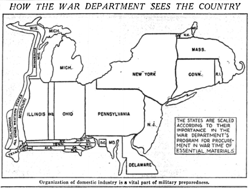
How important each state was to the War Department, from 1940.
(media.piefed.world)
Back when we used to have huge manufacturing facilities in those “important” states.
I'm so happy to be on this map, it makes the ground water pollution worth it, who cares about the increased cancer rate now /s
Some things never change, huh?
Finally there’s enough room on the map to spell out “Massachusetts” and they still didn’t, out of spite.
They couldn't Google it back then.
Couldn't spell it.
Lmfao “ALL OTHER WESTERN STATES”
"and the rest"

🎶 Cut us loose! Cut us loose! We can handle dust storms and only FDR gives a [hoot] about us Okies anyways! 🎶
How did Connecticut beat California? This was during ww2
I feel like they're selling California short on this one.
That was 1940, I suspect a map from 1945 would be substantially different
Yeah, it would appear their plan was just to amputate everything except the NE, maybe because it would be indefensible.
Never mind all the infantry training in the Midwest for island hopping in the Pacific! This is 1940, we've got to focus on the war...
Yeah, but this map shows military procurement - the northeast was vastly more industrialized at that point.
I assume they have another map for warm body procurement.
Or the training the air force did before dropping the bomb on Japan.
Thank you! :::pointing dramatically with both hands:::: Welcome to the vast land with a relatively low number of people per square mile. It was designed, by God's good grace, for flying secret stuff, it starts in western Oklahoma.
So I'm not lazy and useless, I'm just living up to my state's strategic importance
For the map enthused!
Rules:
post relevant content: interesting, informative, and/or pretty maps
be nice